|
|
Wildlife habitat, NBWL2
| |
The entire report for NBWL2, including photographs and maps of twelve different sites within the stream section, can be found at www.ultranet.com/ ~balkus_p/stream.htm . The information at this web site was used to produce the following narrative description of stream section NBWL2.
Will's Hole Brook originates from Will's Hole, a quaking bog, that is adjacent to Acton Town Forest. Will's Hole is on the northeastern side of Rte. 2A in North Acton, and the stream flowing from it crosses under Rte. 2A and then parallels this main road until the
|
|
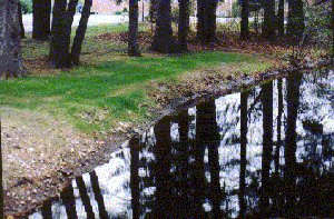
Buffer/Yard Waste/Runoff concerns: No buffer, grass up to edge of stream, erosion, NBWL2. When fertilizers, pesticides, and herbicides are applied to a lawn that runs to the streams’ edge, these materials also end up in the stream.
| |
stream flows into Nashoba Brook, near the junction of Rte. 27 and Rte. 2A (see section NBWL1). Street, lawn, and other runoff are a concern to this stream section. Along much of its length, drainage from the street feeds directly into the stream. Along Rte 2A the stream is bordered by businesses and condominiums.
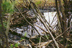
The uppermost part of stream section NBWL2 is not accessible due to swampy conditions resulting from the presence of a beaver lodge, and beaver activity. Moving downstream the stream bottom consists of sand, rocks, and mud. Skunk cabbage, grasses, and overhanging trees are
|
|
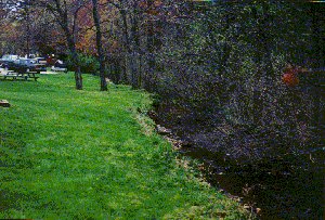
Buffer/Yard Waste/Runoff concerns: Lawn extends to stream, fertilizer, runoff concerns, (from lawn and parking area) NBWL2
| |
present along the banks. The water is clear and three to four inches deep.
Further downstream is a pond, approximately Ľ acre in size, with a mud bottom. The water is clear. Downstream of the pond the stream flows through a pipe under Rte. 2A. The area south of the pipe is very marshy, with grasses and skunk cabbage. The stream is three to four inches deep, and the wetland area is approximately 30 feet by 30 feet. The stream then flows through a heavily wooded area. Large rocks in the water cause
|
|
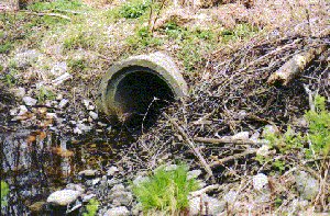
Dams, beavers: Beaver material in pile on right was previously removed from culvert pipe. It has been an ongoing challenge to keep the water flowing freely. NBWL2
| |
some pooling.
Another pond area is present further downstream. This is followed by an area where the stream flows past lawns that run to the waters' edge, with no buffer area to filter out fertilizers, pesticides etc. A little further on is an area where a man-made dam causes the stream to form a pool, that is approximately twelve feet wide and one foot deep. The bottom consists of mud and leaves, and the water is clear. The furthest downstream portion of NBWL2 is about six inches deep, with
|
|
Dams, beavers: Beaver dam previously opened to prevent flooding, NBWL2
| |
a sandy, pebbly bottom and clear water.
|