Welcome to Acton's Stream Team


|


| FPPR1, Pratt's Brook
|
- Upstream Border: High Street @ Valley Road
- Downstream Border: River Street @ Carriage Drive
|
Team: David Downing & Bob Eisengrein
|
|
|
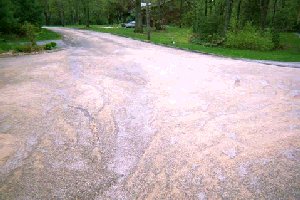
Buffer/Yard Waste/Runoff concerns: Sand being washed from road towards Pratt’s Brook, FPPR1
| |
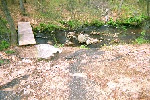
Pratt's Brook enters a larger stream, Fort Pond Brook, at Carriage Drive. It is carried through a pipe under the railroad tracks into a shaded pool. (A moving company has a large storage building here.) On the other side of the tracks, the brook rushes quickly through a boulder and rock strewn area (100' approx.) From a rock pedestrian bridge there are extensive wetlands on both sides of Pratt's Brook to Broadview Road. (There is at least one tributary east of Pratt's Brook.) This is conservation land, but at Broadview Rd. several houses' back
|
|
Buffer/Yard Waste/Runoff concerns: Rain water washes sand (and oil etc. from the road?) into Pratt’s Brook, FPPR1
| |
yards border the wetlands. Further on, the boulders are replaced by smaller rocks, and a lot of fallen trees are in the water. From Broadview Rd. to High Street, the stream narrows to a sandy bottom. About 100' north of High Street, an old footbridge and natural vegetation block the stream. Bordering High Street, there is a small wetlands area.
|
|
|
|
|
|